
REPORT FOR PMR FELLOWSHIP FROM JUNE 2020 - NOVEMBER 2021

JOBIN VARUGHESE
PhD Topic: NATIVE BIODIVERSITY IN EXOTIC, INVASIVE TIMBER LANDSCAPES OF TROPICAL MOUNTAINS
Executive Summary
Mountainous regions are unique elevated landscapes holding half of the global biodiversity hotspots (Kohler & Maselli 2009). The tropical mountains have had pronounced alterations due to increasing land cover changes (Korner & Spehn, 2019). Such modified landscapes get highlighted for their negative spin-offs (Foley et al., 2005). Instead, my study focuses on specific ecological settings that permit the establishment of native species in modified landscapes.
Species distribution on mountains in modified landscapes is constrained mainly by habitat availability and connectivity, but their interaction effects with climate change also play an essential role (Fjeldså et al., 2012; Guo et al., 2018).
Invasive landscapes are primary examples of modified habitats that render mountain biodiversity vulnerable (Colwell et al., 2008; Hoorn et al., 2018; McDougall et al., 2011). Stands of invasive timber are usually considered green deserts with very minimal biodiversity. Given the rapid depletion of natural forests, looking for passive restoration prospects of invasive woody stands for forest fauna, and flora becomes necessary.
Patterns of floral regeneration in the understory of the plantation stands require mapping at a regional scale for effective conservation interventions. Hence, one requires extrapolating understory conditions to a large-scale level using products from satellite data and validating with ground reference data of simultaneous structural properties of under- and overstory vegetation.
Invasive landscapes can spread at a rate of 2-5% per year (Arasumani et al., 2018; Bar et al., 2004) in protected areas, rendering the task of forest managers an enormous challenge, particularly in developing countries of the tropics. Mapping invasion, thus, requires a cheap yet efficient method of sampling large stretches in minimal time by untrained professionals. Therefore, my objectives for the PhD are:
- What are the patterns of landscape change in tropical mountainous regions, and how does the interaction with climate change affect the range?
- What are the specific ecological settings in a modified landscape that permit native faunal biodiversity?
- What vegetation attributes (compositional and structural) or environmental factors predict native understory plant regeneration in invasive timber landscapes?
- Can we use a photo-based technique as an alternative to vegetation attributes in a fast-expanding invasive landscape in tropical mountains?
Chapter 1
Patterns of landscape change in a tropical mountain, and interaction with climate change across the range.
Mountainous regions hold half of the global biodiversity hotspots but cover only 16.5 % to 27% of the total land area (Kohler & Maselli 2009). They contain many endemic and threatened species (Fjeldså et al., 2012), with high species richness, specifically in the tropics rather than in temperate latitudes. Mountains remain highly vulnerable to global change drivers, particularly land-use changes, and invasive species (Colwell et al., 2008; Hoorn et al., 2018). Still, climate change poses moderate but long-term threats to biodiversity at higher elevations, mainly since local climate could vary dramatically over short distances in the mountains (Fjeldså et al. 2012; Fernandes and Price, 1988; Körner, 2004; Colwell et al., 2008). The interaction between them may have a more significant overall impact on biodiversity than either of these drivers operating in isolation (Chazal & Rounsevell, 2009). Thus, when studying changes in species distribution due to the changing climate and land use, it becomes essential to examine their interactions.
The Western Ghats is a chain of mountains running 1600 km parallel to the west coast of Peninsular India, extending between 8° to 21°N. (Robin and Nandini, 2012). None of the studies discussing climate change and landscape change (Rajendran and Kitoh 2008; Varikoden et al. 2018; Kale et al., 2016) look at the interactions between climate change and land cover change. Our study seeks to fill the gaps in the literature on interactions of climate change and landscape change of Western Ghats with these objectives:
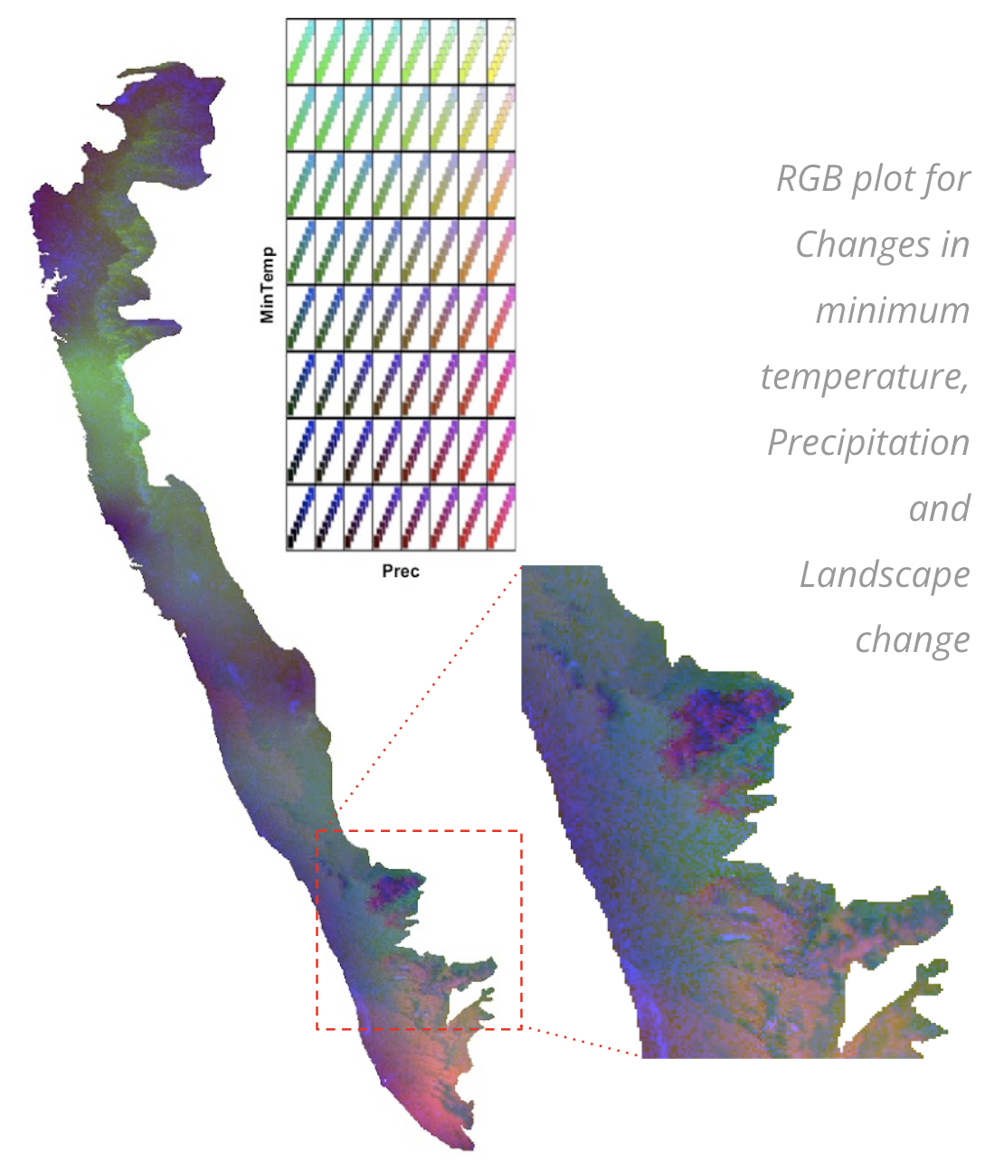
Map the change in climatic parameters within the next 30 years across elevational and latitudinal gradients in the Western Ghats and locate the sensitive zones. We find the plains to have the most significant change in landscape.
Map the change in the landscape across the Western Ghats and locate the sensitive zones. We find the parts closer to the equator to face a stark shift in the temperature in the future.
Map the interaction of CC and LC and locate the sensitive zones. We find mid-elevations and mountain tops (near the equator) most vulnerable to their integrated effects.
Work completed: 90% of data analyses are complete; 80% of writing is done.
Work done in 2021: Integrated maps of climate and landscape change to create an RGB plot. Presented in RAC, PMRF review
Target timeline: January 2022
Presentation of interim results: RAC committee
Course correction suggested: include landscape change predictions for the future.
Collaborator: Guha Dharmarajan, University of Georgia
Chapter 2
Attributes of modified landscape that permit the return of faunal biodiversity
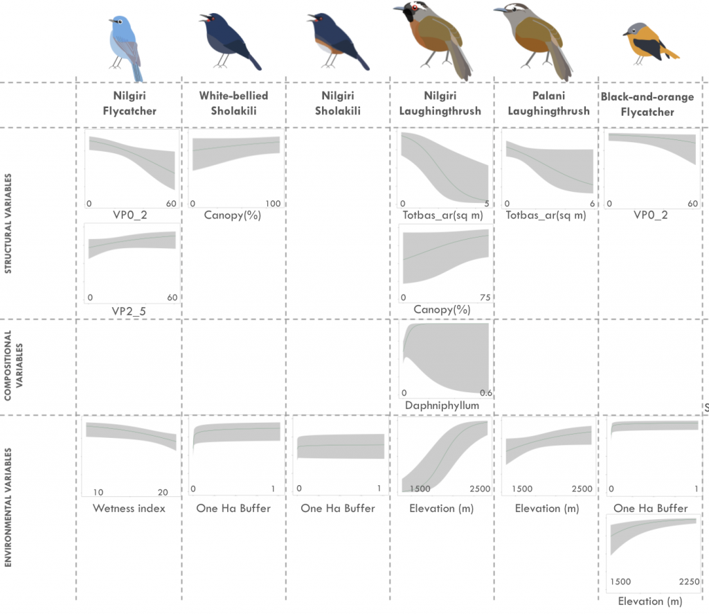
Forest species in the tropics use plantation forests extensively, but the quality of exotic invasive stands to rainforest animals has remained poorly understood (Brook et al., 2006; Wright and Muller-Landau, 2006a,b; Chazdon et al., 2009). Widespread on global mountains, it becomes necessary to look for conservational aspects of stands of invasive trees, given the rapid depletion of natural forests. Birds being conspicuous and widespread, are an excellent system to study succession in such novel habitats. Understory birds are the first guild to colonize undisturbed regions. But their presence is strongly affected by the age of stands and proximity to shola forests. Within the guild, while the generalists thrive, no studies have explained the succession of forest specialists into exotic invasive stands. Our study aims at studying the ecological settings in these modified habitats that favour both generalist and specialist understory birds. The conservation of such species requires understanding the spatial and structural aspects of such locations. Shola Sky islands is an excellent system to study the establishing native faunal biodiversity in exotic plantations. The heavily modified landscape of Shola Sky Islands has created a complex wooded landscape of Shola forests and invasive stands. SSI are home to several threatened, endemic specialists and range-restricted birds that inhabit these novel habitats (Zarri et al., 2008). Thus, my primary question is: What are the specific ecological settings in a modified landscape that permit the establishment of faunal biodiversity?My objectives are:
Where does the faunal succession occur? We find the succession present in stands with greater basal area, height and canopy cover.
What could be the drivers of these establishments? We find the succession present in stands with a complex vegetation profile and proximity to shola forests.
Work completed: Field: 70%; Preliminary analyses done at 2 stages
Data from 239 plots collected (Palani, Anamalai & Nilgiris), 242 plots remain
Work done in 2021: Data from 100 plots collected across Nilgiris and Munnar, analyses done, results discussed in ESA conference 2021, and RAC 2021
Target timeline: July 2022
Presentation of interim results: ESA conference 2021, NSAB conference 2020, IISER Tirupati Biology Day meet 2020, RAC committee 2021, PMRF review
Course correction included: Abundance to be modelled, Distribution maps
Collaborator: Devcharan Jathanna, WCS-India
Chapter 3
Factors that predict native understory regeneration in invasive timber landscapes
Despite their negative impacts, plantations and invasive timber stands co-occur with germinating shade-tolerant native forest tree species (Parrotta, 1993). However, the establishment of seedlings into mature saplings under invasive stands is rarely documented (ref). With rapidly depleting natural forests, identifying factors responsible for controlling the natural regeneration of native trees under the stands of invasive exotic timber stands is essential to realize the prospective role of existing plantation stands as catalysts of succession.
Regeneration characteristics may vary across plantations depending on several structural factors and environmental/ topographical factors (Thijs et al., 2014). Regeneration under the stands of certain invasive species has proved to be similar to that occurring under native tree stands (Geldenhuys et al., 2017; Abugre et al., 2019). Still, some studies speculate the arrest of the establishment of native seedlings in invasive stands (Tassin et al., 2009; Thijs et al., 2014). The ecological settings when native regeneration occurs is unclear.
For conservation, it is crucial to map regeneration to a regional scale by procuring products from satellite data and validating with ground reference data (Gopalakrishnan et al., 2017) of simultaneous structural properties of under- and overstory vegetation.
The Shola Sky Islands (SSIs) invasion is spreading at an alarming rate (Arasumani et al., 2019). For nuanced biodiversity conservation, it is vital to assess the attributes responsible for the establishment of native regeneration in invasive stands and map them across the entire landscape. Our objectives in this study are:
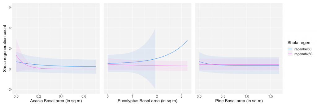
What are the compositional and structural attributes that contribute to the establishment of native regeneration? We find the invasive stands of Acacia and Pine to show a reduced establishment of forest species regeneration while canopy cover, total basal area, and forest height to correlate positively.
What are the environmental variables that contribute to the establishment of native regeneration? We see that the invasive stands under a greater rainfall regime, and proximity to Shola has increased forest species’ establishment.
Can the correlation between compositional and structural attributes of undergrowth and canopy be generalized to a landscape level through satellite imagery? We expect the correlation to be high, and thus, we can achieve extrapolation.
Work completed: 70%; Data from 210 plots collected (Palani, Anamalai & Nilgiris), 242 plots remain
Work done in 2021: Data collected for 80 grids, set of analyses done for 210 plots, preliminary results presented at PMRF review 2021
Target timeline: July 2022
Presentation of interim results: RAC committee 2021, PMRF review.
Course correction included: Distribution maps
Collaborator: Arundhati Das, NCBS
Chapter 4
A photo-based alternative to assess vegetation attributes in tropical forests
Plantations can act as woodland ecosystems, alleviating forest regeneration (Brockerhoff et al., 2008). Hence, monitoring the understory growth becomes essential to understanding the long-term forest dynamics. Canopy structure and forest successional stage are two essential characteristics that can serve as predictor variables in a regenerating understory distribution modelling approach (Martinuzzi et al., 2009).
Satellite remote sensing data on the above canopy characteristics of the area of interest can be derived at an excellent temporal resolution. However, collecting below-canopy data over a regional scale can be challenging. Collecting individual tree attributes in each sampling plot can be extremely time consuming and labour intensive (Wang & Kershaw, 2020).
Several sampling methods can obtain precise data with efficient field processes. Terrestrial LiDAR uses an efficient active remote-sensing technique, but the cost of the instrument can be highly constraining. 360° spherical camera combined with the angle count sampling (ACS) (Bitterlich, 1984) technique has offered an inexpensive and effective option for obtaining direct stand-level measurements (Wang & Kershaw, 2020). Such measurements, however, are in temperate plantations with simple vegetation structure. Translating these techniques to tropical regions can pose several challenges. Effects of understory vegetation, inconsistent light exposure and sloping terrain can produce heavy deviations from the results obtained.
Shola forests of Western Ghats provide a good site for testing the feasibility of using this sampling method in tropical forests and plantations. Exotic plantations with heavy undergrowth, terrains with slopes > 45°, and variable lighting conditions affected by thick canopy cover or bouts of heavy mists render these wooded areas challenging to use spherical cameras for sampling.
Invasive Acacia, studied using satellite data, is known to spread at a rate of 2-5% per year; (Arasumani et al., 2018; Bar et al., 2004). The Tamil Nadu and Kerala Forest departments have mandated a removal of these invasives, starting with regions with low structural complexity. However there remains an enormous challenge of mapping the invasion across a large region. Hence, it is necessary to seek quicker and cheaper instruments to survey vegetational structure in tropical mountains.
So, I ask: Would a photo-based sampling technique be a more practical (faster and efficient) alternative instead of a terrestrial LiDAR to mensurate vegetation attributes in a fast-expanding invasive landscape in tropical mountains?
The objectives of the study are:
How would the use of spherical images to estimate angle-count sampling be correlated to manually collected samples in continuous gradation of light intensity, slope and undergrowth? We expect the visibility to reduce with higher mist conditions and increasing undergrowth and produce erroneous results with steeper slopes, affecting the correlations significantly.
How much more time-efficient would it be to use spherical images to estimate angle-count sampling than collecting vegetation data by LiDAR or manual sampling? We expect the ACS with 360 cameras will be more time-efficient than LiDAR (post-processing included) and manual sampling.
Work completed: 20%; only trial data collected
Work done in 2021: 360 camera Data collected for 60 plots, preliminary data analyses
Target timeline: Dec 2023
Presentation of interim results: NA.
Course correction included: NA.
Collaborator: John Kershaw, UNB Canada
Other PMRF Requirements (teaching):
Year 1: Jan 2020 – Dec 2020: 10 Hours of teaching
Year 2: Jan 2021 – Dec 2021: Currently 13.5 hours of teaching, 24 hours scheduled for November-December
Class teaching experience on Mapping Climate change across Palni Hills for Std XII students at Kodaikanal International School, Kodaikanal in August to November 2021. 11 hours
Class teaching experience on Regeneration Ecology for M.Sc. students at Department of Botany, St. Francis College of Women, Hyderabad in September 2021. 1 hour
Class teaching experience on Avian Ecology for M.Sc. students at Department of Ecology, Pondicherry University, Pondicherry in June 2021. 1 hour
Class teaching experience on Ecology for M.Sc. students at Department of Wildlife Biology, Government Arts College, Udhagamandalam in September-October 2020. 8 hours
Class teaching experience on Landscape design for B.Arch. students (Semester V) at Institute of Architecture & Planning, Nirma University in October 2020. 1 hour
Webinar experience on Birds in Natural and Urban Landscapes in the July Web-Talk Series on ‘Ecologically Sensitive Design Solutions’ by Indian Society of Landscape Architects (ISOLA)-Bangalore in July 2020. 1 hour
PMRF review on 27th October 2021:
1st RAC meeting on 16th April 2021:
Comprehensive Exam Seminar on 20th July 2021:
Field Work:
- Re-initiated in the hills of Berijam, Kodaikanal, Tamil Nadu from 15th November 2021, extended till Mukurthi National Park and Nilgiri Buffer zone. The fieldwork also spilled into Shola National Parks (Pampadum and Mathikettan), Munnar Buffer Forests in Anamalai hills
- Study Site: Field stations were based out of Kodaikanal fieldstation, Pykara Forest guest house, Mukurthi Anti-poaching camps, Pampadum Shola National Park guest house, Munnar forest rest house and Mathikettan Shola National Park guest house to cover a large part of the 1500 sq km landscape.
- Assisting Team members: Two field assistants and eighteen interns assisted me in collecting data
- Time period: Six months – November 2020 to April 2021
- Plots sampled: 100 nested square plots of 1ha and 4ha across the landscape (both bird survey and vegetation sampling).
- Challenges faced: We had to discontinue our field work in the months of May because of the second wave of Covid.
Publications and Presentations
- Jude, D., Aravind, P.S., Chanda, R., Subash, M., Jobin, V., (2021) Provisioning behaviour of Malabar Starling Sturnia blythii. Indian Birds. Manuscript accepted.
- Jobin, V., Chanda, R., Harikrishnan, CP, Lawrence, S., Arasumani, M., Jathanna, D., Robin, VV, (5th August 2021) “What are the specific ecological settings in a novel, invasive landscape that permit native avian succession?”, Poster presentation at Ecological Society of America.
- Jobin, V., Chanda, R., Harikrishnan, CP, Lawrence, S., Arasumani, M., Jathanna, D., Robin, VV, (August 2022) “How do understory birds respond to the impacts of exotic tree invasion in the Shola Sky Islands?”, Talk Presentation at International Ornithological Congress 2022, Abstract accepted.
Papers in preparation
- Jobin, V., Chanda, R., Harikrishnan, CP, Lawrence S., Das, A., Robin, VV., (2021) What characters permit native forest regeneration in exotic, invasive timber stands across the entire Shola Sky Island habitat? Manuscript in preparation.
- Jobin, V., Meera, M., Dharmarajan, G., Gupta, P., Mukherjee, S., Robin, VV., (2021) Understanding the Patterns of climate and landscape change in the Western Ghats on conservation of biodiversity. Manuscript in preparation.